Picacho Peak
Hike to Picacho Peak via Hunter Trail in Picacho Peak State Park #Hiking #Desert #Mountain
- Distance: 4.6 Km
- Elevation gain: 709 m
- Maximum elevation: 950 m
- Elevation loss: 708 m
- Minimum elevation: 608 m
- Moving time: 2 h 12 m
- Moving speed: 2.1 Km/h
- Maximum speed: 5.8 Km/h
- Total time: 3 h 28 m
- Global speed: 1.3 Km/h
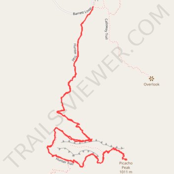
Interactive trail map
Trail profile
- Distance: 4.6 Km
- Elevation gain: 709 m
- Maximum elevation: 950 m
- Elevation loss: 708 m
- Minimum elevation: 608 m
- Moving time: 2 h 12 m
- Moving speed: 2.1 Km/h
- Maximum speed: 5.8 Km/h
- Total time: 3 h 28 m
- Global speed: 1.3 Km/h
About this trail
Name: Picacho Peak trail, distance, elevation, map, profile, GPS track
Start: Hunter Trail, Pinal County, Arizona, 85141, United States (32.64265 -111.40248)
End: Hunter Trail, Pinal County, Arizona, 85141, United States (32.64263 -111.40248)
Coordinates: 32.63478 -111.40516 32.64265 -111.40052
Other hiking, mountain biking, running and outdoor activity trails
Click on a trail to view its statistics, map and profile.
Picacho Peak via Hunter Trail in Picacho Peak State Park
United States > Arizona > Pinal County
The Hunter Trail to Picacho Peak offers a challenging yet rewarding hiking experience. As you ascend, you'll encounter steep switchbacks and sections requiring the use of fixed cables to navigate exposed rock faces. Upon reaching the summit, panoramic views of the Sonoran Desert, including expansive saguaro…
Distance: 5.4 Km • Elevation gain: 695 m • Maximum elevation: 951 m