Thank you for supporting this site ❤️
Make a donation
Make a donation
Gear up for your next adventure:
As an Amazon Associate, this site earns from qualifying purchases at no extra cost to you.
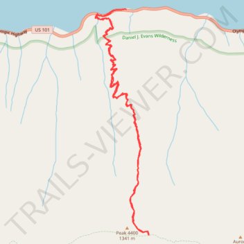
Aurora Creek Trail
- Distance: 11.4 Km
- Elevation gain: 1,195 m
- Maximum elevation: 1,305 m
- Elevation loss: 1,221 m
- Minimum elevation: 173 m
- Moving time: 4 h 21 m
- Moving speed: 2.6 Km/h
- Maximum speed: 8.4 Km/h
- Total time: 5 h 39 m
- Global speed: 2.0 Km/h
Interactive trail map
Thank you for supporting this site ❤️
Make a donation
Make a donation
Gear up for your next adventure:
As an Amazon Associate, this site earns from qualifying purchases at no extra cost to you.
Trail profile
- Distance: 11.4 Km
- Elevation gain: 1,195 m
- Maximum elevation: 1,305 m
- Elevation loss: 1,221 m
- Minimum elevation: 173 m
- Moving time: 4 h 21 m
- Moving speed: 2.6 Km/h
- Maximum speed: 8.4 Km/h
- Total time: 5 h 39 m
- Global speed: 2.0 Km/h
Thank you for supporting this site ❤️
Make a donation
Make a donation
Gear up for your next adventure:
As an Amazon Associate, this site earns from qualifying purchases at no extra cost to you.
About this trail
Name: Aurora Creek Trail trail, distance, elevation, map, profile, GPS track
Start: 225103, Olympic Highway, Clallam County, Washington, 98363, United States (48.05189 -123.83658)
End: Olympic Highway, Clallam County, Washington, United States (48.05202 -123.83414)
Coordinates: 48.02360 -123.84007 48.05208 -123.82989
Thank you for supporting this site ❤️
Make a donation
Make a donation
Gear up for your next adventure:
As an Amazon Associate, this site earns from qualifying purchases at no extra cost to you.