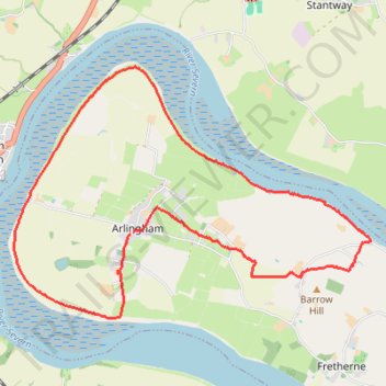
Arlingham Loop Walk
- Distance: 13.6 Km
- Elevation gain: 71 m
- Maximum elevation: 40 m
- Elevation loss: 70 m
- Minimum elevation: 5 m
- Moving time: 2 h 52 m
- Moving speed: 4.7 Km/h
- Maximum speed: 7.9 Km/h
- Total time: 3 h 25 m
- Global speed: 4.0 Km/h
Interactive trail map
Trail profile
- Distance: 13.6 Km
- Elevation gain: 71 m
- Maximum elevation: 40 m
- Elevation loss: 70 m
- Minimum elevation: 5 m
- Moving time: 2 h 52 m
- Moving speed: 4.7 Km/h
- Maximum speed: 7.9 Km/h
- Total time: 3 h 25 m
- Global speed: 4.0 Km/h
About this trail
Name: Arlingham Loop Walk trail, distance, elevation, map, profile, GPS track
Coordinates: 51.78660 -2.44589 51.81425 -2.38224
Other hiking, mountain biking, running and outdoor activity trails
Click on a trail to view its statistics, map and profile.
Dean2023-311
United Kingdom > England > Oxfordshire > Oxford
Distance: 310.3 Km • Elevation gain: 3,366 m • Maximum elevation: 290 m
Arlingham Loop
United Kingdom > England > Gloucestershire > Stroud > Arlingham
Distance: 18.1 Km • Elevation gain: 71 m • Maximum elevation: 24 m