Thank you for supporting this site ❤️
Make a donation
Make a donation
Gear up for your next adventure:
As an Amazon Associate, this site earns from qualifying purchases at no extra cost to you.
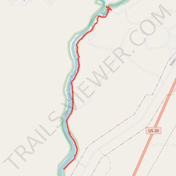
Box Canyon Trail to waterfall
- Distance: 7.1 Km
- Elevation gain: 49 m
- Maximum elevation: 1,915 m
- Elevation loss: 48 m
- Minimum elevation: 1,892 m
- Moving time: 1 h 50 m
- Moving speed: 3.9 Km/h
- Maximum speed: 5.7 Km/h
- Total time: 2 h 21 m
- Global speed: 3.0 Km/h
Interactive trail map
Thank you for supporting this site ❤️
Make a donation
Make a donation
Gear up for your next adventure:
As an Amazon Associate, this site earns from qualifying purchases at no extra cost to you.
Trail profile
- Distance: 7.1 Km
- Elevation gain: 49 m
- Maximum elevation: 1,915 m
- Elevation loss: 48 m
- Minimum elevation: 1,892 m
- Moving time: 1 h 50 m
- Moving speed: 3.9 Km/h
- Maximum speed: 5.7 Km/h
- Total time: 2 h 21 m
- Global speed: 3.0 Km/h
Thank you for supporting this site ❤️
Make a donation
Make a donation
Gear up for your next adventure:
As an Amazon Associate, this site earns from qualifying purchases at no extra cost to you.
About this trail
Name: Box Canyon Trail to waterfall trail, distance, elevation, map, profile, GPS track
Start: Box Canyon Trail, Island Park, Fremont County, Idaho, United States (44.41415 -111.39202)
Coordinates: 44.38945 -111.40217 44.41473 -111.39169
Thank you for supporting this site ❤️
Make a donation
Make a donation
Gear up for your next adventure:
As an Amazon Associate, this site earns from qualifying purchases at no extra cost to you.