Import a GPX file

Falcons Lookout via Ironbark Gorge Track in Werribee Gorge State Park

  • Distance: 4.0 Km
  • Elevation gain: 213 m
  • Maximum elevation: 397 m
  • Elevation loss: 212 m
  • Minimum elevation: 305 m

Interactive trail map

Trail profile

  • Distance: 4.0 Km
  • Elevation gain: 213 m
  • Maximum elevation: 397 m
  • Elevation loss: 212 m
  • Minimum elevation: 305 m

About this trail
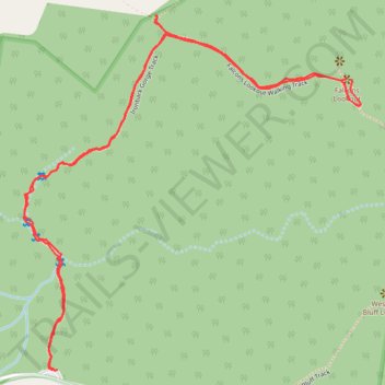
Name: Falcons Lookout via Ironbark Gorge Track in Werribee Gorge State Park trail, distance, elevation, map, profile, GPS track

Start: Ironbark Gorge Trailhead, Ironbark Gorge Track, Ingliston, Victoria, 3342, Australia (-37.66558 144.33451)

End: Ironbark Gorge Trailhead, Ironbark Gorge Track, Ingliston, Victoria, 3342, Australia (-37.66558 144.33437)

Coordinates: -37.66559 144.33351 -37.65708 144.34368

Gear up for your next adventure:

🥾Waterproof Hiking Boots - Boots keeping your feet dry in wet conditions
🔦LED Headlamp - Hands-free lighting for early morning starts or late finishes
🧢Hiking Hat - Sun-protective and breathable hats for long treks
🧰Multitool Knife - Compact and versatile tool for outdoor use
🔋Emergency Crank Radio - Weather alerts and power without needing batteries

As an Amazon Associate, this site earns from qualifying purchases at no extra cost to you.