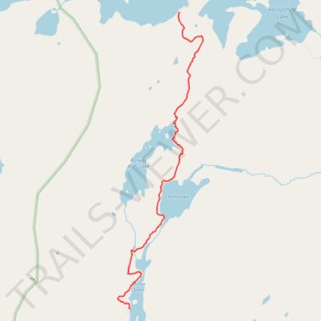
Section of Powwow Trail from Mirror Lake to Lake Three
- Distance: 5.8 Km
- Elevation gain: 60 m
- Maximum elevation: 496 m
- Elevation loss: 82 m
- Minimum elevation: 458 m
- Moving time: 2 h 11 m
- Moving speed: 2.6 Km/h
- Maximum speed: 10.7 Km/h
- Total time: 3 h 11 m
- Global speed: 1.8 Km/h
Interactive trail map
Trail profile
- Distance: 5.8 Km
- Elevation gain: 60 m
- Maximum elevation: 496 m
- Elevation loss: 82 m
- Minimum elevation: 458 m
- Moving time: 2 h 11 m
- Moving speed: 2.6 Km/h
- Maximum speed: 10.7 Km/h
- Total time: 3 h 11 m
- Global speed: 1.8 Km/h
About this trail
Name: Section of Powwow Trail from Mirror Lake to Lake Three trail, distance, elevation, map, profile, GPS track
Start: Powwow Trail, Stony River Township, Lake County, Minnesota, United States (47.84302 -91.44834)
End: Powwow Trail, Stony River Township, Lake County, Minnesota, United States (47.87785 -91.43978)
Coordinates: 47.84302 -91.45054 47.87785 -91.43561