Import a GPX file

Whiting Ranch Wilderness Park

Hike from Foothill Ranch through Whiting Ranch Wilderness Park via Borrego Canyon Trail and Red Rock Canyon Trail. #Hiking #Canyon #Nature #Forest #Park

  • Distance: 3.4 Km
  • Elevation gain: 170 m
  • Maximum elevation: 396 m
  • Elevation loss: 22 m
  • Minimum elevation: 248 m

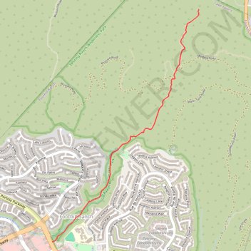
Interactive trail map

Trail profile

  • Distance: 3.4 Km
  • Elevation gain: 170 m
  • Maximum elevation: 396 m
  • Elevation loss: 22 m
  • Minimum elevation: 248 m

About this trail

Gear up for your next adventure:

🥾Hiking Gaiters - Protect legs and shoes from mud, snow, and debris
Lightweight Backpacking Tent - Compact tent for efficient hiking trips
🔦UV Flashlight - Detect minerals or specific insects in the dark
🥾Light Hiking Boots - Lightweight and comfortable boots for day hikes
🧊Insulated Water Bottle - Keeps drinks cold in summer and prevents freezing in winter

As an Amazon Associate, this site earns from qualifying purchases at no extra cost to you.