Thank you for supporting this site ❤️
Make a donation
Make a donation
Gear up for your next adventure:
As an Amazon Associate, this site earns from qualifying purchases at no extra cost to you.
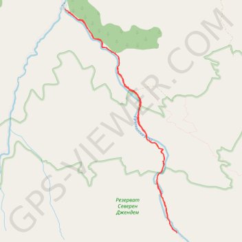
Vidimsko praskalo
- Distance: 12.2 Km
- Elevation gain: 568 m
- Maximum elevation: 1,255 m
- Elevation loss: 580 m
- Minimum elevation: 703 m
- Moving time: 3 h 48 s
- Moving speed: 4.1 Km/h
- Maximum speed: 11.0 Km/h
- Total time: 3 h 32 m
- Global speed: 3.5 Km/h
Interactive trail map
Thank you for supporting this site ❤️
Make a donation
Make a donation
Gear up for your next adventure:
As an Amazon Associate, this site earns from qualifying purchases at no extra cost to you.
Trail profile
- Distance: 12.2 Km
- Elevation gain: 568 m
- Maximum elevation: 1,255 m
- Elevation loss: 580 m
- Minimum elevation: 703 m
- Moving time: 3 h 48 s
- Moving speed: 4.1 Km/h
- Maximum speed: 11.0 Km/h
- Total time: 3 h 32 m
- Global speed: 3.5 Km/h
Thank you for supporting this site ❤️
Make a donation
Make a donation
Gear up for your next adventure:
As an Amazon Associate, this site earns from qualifying purchases at no extra cost to you.
About this trail
Name: Vidimsko praskalo trail, distance, elevation, map, profile, GPS track
Start: Apriltsi, Lovech, Bulgaria (42.77941 24.92287)
End: Екопътека "По стъпките на балканджиите", Apriltsi, Lovech, 5650, Bulgaria (42.78004 24.92212)
Coordinates: 42.73924 24.92212 42.78004 24.94986
Thank you for supporting this site ❤️
Make a donation
Make a donation
Gear up for your next adventure:
As an Amazon Associate, this site earns from qualifying purchases at no extra cost to you.