רומאים צרפתיים
לאחרונה הריצות מתקיימות במקומות שאין ממש מסלולים מסומנים ולאחריהן נוספים הממסלולים. כזו גם הריצה הזו.
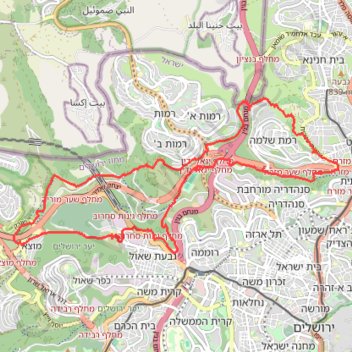
- Distance: 21.3 Km
- Elevation gain: 622 m
- Maximum elevation: 811 m
- Elevation loss: 622 m
- Minimum elevation: 558 m
- Moving time: 3 h 25 m
- Moving speed: 6.2 Km/h
- Maximum speed: 15.3 Km/h
- Total time: 3 h 47 m
- Global speed: 5.6 Km/h
Interactive trail map
Trail profile
- Distance: 21.3 Km
- Elevation gain: 622 m
- Maximum elevation: 811 m
- Elevation loss: 622 m
- Minimum elevation: 558 m
- Moving time: 3 h 25 m
- Moving speed: 6.2 Km/h
- Maximum speed: 15.3 Km/h
- Total time: 3 h 47 m
- Global speed: 5.6 Km/h
About this trail
Name: רומאים צרפתיים trail, distance, elevation, map, profile, GPS track
Coordinates: 31.79158 35.16484 31.81817 35.23086
Other hiking, mountain biking, running and outdoor activity trails
Click on a trail to view its statistics, map and profile.
North West Jerusalem trail running
Israel > Jerusalem District > Jerusalem
Distance: 22.9 Km • Elevation gain: 632 m • Maximum elevation: 886 m
סובב רמות ונבי סמואל
Israel > Jerusalem District > Jerusalem
Exploration trail run went beyond expectations
Distance: 18.6 Km • Elevation gain: 515 m • Maximum elevation: 886 m