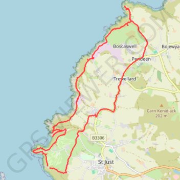
Boscaswell, St Just
- Distance: 18.2 Km
- Elevation gain: 540 m
- Maximum elevation: 139 m
- Elevation loss: 531 m
- Minimum elevation: 0 m
Interactive trail map
Trail profile
- Distance: 18.2 Km
- Elevation gain: 540 m
- Maximum elevation: 139 m
- Elevation loss: 531 m
- Minimum elevation: 0 m
About this trail
Name: Boscaswell, St Just trail, distance, elevation, map, profile, GPS track
Coordinates: 50.12126 -5.70999 50.16498 -5.66269
Other hiking, mountain biking, running and outdoor activity trails
Click on a trail to view its statistics, map and profile.
Pendeen to Porthmeor
United Kingdom > England > Cornwall > St Just > Boscaswell
Distance: 17.6 Km • Elevation gain: 578 m • Maximum elevation: 140 m