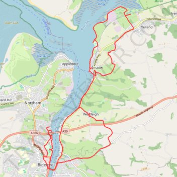
Bideford Instow
- Distance: 26.6 Km
- Elevation gain: 352 m
- Maximum elevation: 86 m
- Elevation loss: 347 m
- Minimum elevation: 0 m
- Moving time: 6 h 28 m
- Moving speed: 4.1 Km/h
- Maximum speed: 7.4 Km/h
- Total time: 7 h 24 m
- Global speed: 3.6 Km/h
Interactive trail map
Trail profile
- Distance: 26.6 Km
- Elevation gain: 352 m
- Maximum elevation: 86 m
- Elevation loss: 347 m
- Minimum elevation: 0 m
- Moving time: 6 h 28 m
- Moving speed: 4.1 Km/h
- Maximum speed: 7.4 Km/h
- Total time: 7 h 24 m
- Global speed: 3.6 Km/h
About this trail
Name: Bideford Instow trail, distance, elevation, map, profile, GPS track
Coordinates: 51.01617 -4.20788 51.07424 -4.15662
Other hiking, mountain biking, running and outdoor activity trails
Click on a trail to view its statistics, map and profile.
Northam Loop
United Kingdom > England > Devon > Torridge District > Abbotsham
Distance: 28.0 Km • Elevation gain: 447 m • Maximum elevation: 96 m