Import a GPX file

Trail, Sugar Loaf Mountain, Sooke Hills, Langford, BC

  • Distance: 8.4 Km
  • Elevation gain: 353 m
  • Maximum elevation: 333 m
  • Elevation loss: 355 m
  • Minimum elevation: 143 m
  • Moving time: 2 h 25 m
  • Moving speed: 3.5 Km/h
  • Maximum speed: 8.0 Km/h
  • Total time: 3 h 31 m
  • Global speed: 2.4 Km/h

Interactive trail map

Trail profile

  • Distance: 8.4 Km
  • Elevation gain: 353 m
  • Maximum elevation: 333 m
  • Elevation loss: 355 m
  • Minimum elevation: 143 m
  • Moving time: 2 h 25 m
  • Moving speed: 3.5 Km/h
  • Maximum speed: 8.0 Km/h
  • Total time: 3 h 31 m
  • Global speed: 2.4 Km/h

About this trail
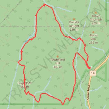
Name: Trail, Sugar Loaf Mountain, Sooke Hills, Langford, BC trail, distance, elevation, map, profile, GPS track

Start: Sooke Flowline, Metchosin, Capital Regional District, British Columbia, V9B 4R3, Canada (48.41711 -123.58491)

End: Sooke Flowline, Metchosin, Capital Regional District, British Columbia, V9B 4R3, Canada (48.41697 -123.58509)

Coordinates: 48.41027 -123.60532 48.42900 -123.58491

Topography: Capital Regional District topographic map, elevation, terrain

Other hiking, mountain biking, running and outdoor activity trails

Click on a trail to view its statistics, map and profile.
Langford - Matheson Lake

Canada > British Columbia > Capital Regional District > Langford

Vancouver Island. #Bike #Vancouver

Distance: 16.7 Km • Elevation gain: 144 m • Maximum elevation: 80 m

Gear up for your next adventure:

🧦Merino Wool Socks - Moisture-wicking comfort for long-distance hiking
🎒Backpack Rain Cover - External shield to keep your entire pack dry
🛶Waterproof Dry Bags - Keep electronics and clothes dry during river crossings
🧥Waterproof Pants - Keep dry during rainy hiking conditions
🕯️Camping Lantern - Illuminates your entire campsite with high-efficiency LEDs

As an Amazon Associate, this site earns from qualifying purchases at no extra cost to you.