Thank you for supporting this site ❤️
Make a donation
Make a donation
Gear up for your next adventure:
As an Amazon Associate, this site earns from qualifying purchases at no extra cost to you.
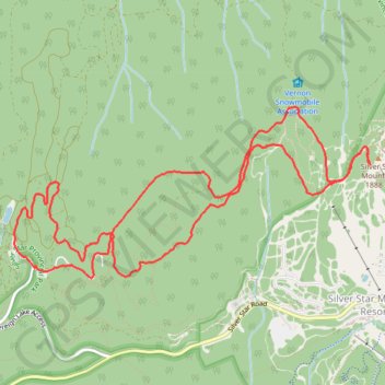
Silver Star Mountain
Silver Star Provincial Park. #Hiking #Loop #SilverStar
- Distance: 10.8 Km
- Elevation gain: 274 m
- Maximum elevation: 1,882 m
- Elevation loss: 274 m
- Minimum elevation: 1,663 m
Interactive trail map
Thank you for supporting this site ❤️
Make a donation
Make a donation
Gear up for your next adventure:
As an Amazon Associate, this site earns from qualifying purchases at no extra cost to you.
Trail profile
- Distance: 10.8 Km
- Elevation gain: 274 m
- Maximum elevation: 1,882 m
- Elevation loss: 274 m
- Minimum elevation: 1,663 m
Thank you for supporting this site ❤️
Make a donation
Make a donation
Gear up for your next adventure:
As an Amazon Associate, this site earns from qualifying purchases at no extra cost to you.
About this trail
Name: Silver Star Mountain trail, distance, elevation, map, profile, GPS track
Coordinates: 50.36024 -119.10482 50.37248 -119.06486
Topography: Area C (Silver Star) topographic map, elevation, terrain
Thank you for supporting this site ❤️
Make a donation
Make a donation
Gear up for your next adventure:
As an Amazon Associate, this site earns from qualifying purchases at no extra cost to you.
Other hiking, mountain biking, running and outdoor activity trails
Click on a trail to view its statistics, map and profile.