Point Nepean National Park
- Distance: 63.6 Km
- Elevation gain: 669 m
- Maximum elevation: 42 m
- Elevation loss: 666 m
- Minimum elevation: 0 m
- Moving time: 3 h 25 m
- Moving speed: 18.6 Km/h
- Maximum speed: 80.0 Km/h
- Total time: 4 h 38 m
- Global speed: 13.7 Km/h
Interactive trail map
Trail profile
- Distance: 63.6 Km
- Elevation gain: 669 m
- Maximum elevation: 42 m
- Elevation loss: 666 m
- Minimum elevation: 0 m
- Moving time: 3 h 25 m
- Moving speed: 18.6 Km/h
- Maximum speed: 80.0 Km/h
- Total time: 4 h 38 m
- Global speed: 13.7 Km/h
About this trail
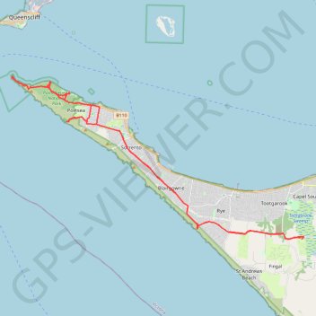
Name: Point Nepean National Park trail, distance, elevation, map, profile, GPS track
Coordinates: -38.39930 144.65208 -38.30306 144.87306
Other hiking, mountain biking, running and outdoor activity trails
Click on a trail to view its statistics, map and profile.
Walk in Rye via Orr Point
Australia > Victoria > Melbourne
Distance: 6.0 Km • Elevation gain: 141 m • Maximum elevation: 34 m