Thank you for supporting this site ❤️
Make a donation
Make a donation
Gear up for your next adventure:
As an Amazon Associate, this site earns from qualifying purchases at no extra cost to you.
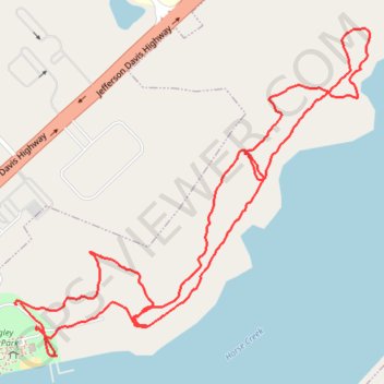
Walking at Langley Pond Park
- Distance: 3.5 Km
- Elevation gain: 47 m
- Maximum elevation: 71 m
- Elevation loss: 47 m
- Minimum elevation: 54 m
- Moving time: 46 m 40 s
- Moving speed: 4.5 Km/h
- Maximum speed: 8.6 Km/h
- Total time: 49 m 48 s
- Global speed: 4.2 Km/h
Interactive trail map
Thank you for supporting this site ❤️
Make a donation
Make a donation
Gear up for your next adventure:
As an Amazon Associate, this site earns from qualifying purchases at no extra cost to you.
Trail profile
- Distance: 3.5 Km
- Elevation gain: 47 m
- Maximum elevation: 71 m
- Elevation loss: 47 m
- Minimum elevation: 54 m
- Moving time: 46 m 40 s
- Moving speed: 4.5 Km/h
- Maximum speed: 8.6 Km/h
- Total time: 49 m 48 s
- Global speed: 4.2 Km/h
Thank you for supporting this site ❤️
Make a donation
Make a donation
Gear up for your next adventure:
As an Amazon Associate, this site earns from qualifying purchases at no extra cost to you.
About this trail
Name: Walking at Langley Pond Park trail, distance, elevation, map, profile, GPS track
Coordinates: 33.52438 -81.84560 33.53112 -81.83684
Thank you for supporting this site ❤️
Make a donation
Make a donation
Gear up for your next adventure:
As an Amazon Associate, this site earns from qualifying purchases at no extra cost to you.