Import a GPX file

Lake Macbride Beach to Dam Trail

  • Distance: 2.1 Km
  • Elevation gain: 39 m
  • Maximum elevation: 233 m
  • Elevation loss: 49 m
  • Minimum elevation: 213 m
  • Moving time: 27 m 9 s
  • Moving speed: 4.6 Km/h
  • Maximum speed: 6.2 Km/h
  • Total time: 27 m 9 s
  • Global speed: 4.6 Km/h

Interactive trail map

Trail profile

  • Distance: 2.1 Km
  • Elevation gain: 39 m
  • Maximum elevation: 233 m
  • Elevation loss: 49 m
  • Minimum elevation: 213 m
  • Moving time: 27 m 9 s
  • Moving speed: 4.6 Km/h
  • Maximum speed: 6.2 Km/h
  • Total time: 27 m 9 s
  • Global speed: 4.6 Km/h

About this trail
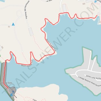
Name: Lake Macbride Beach to Dam Trail trail, distance, elevation, map, profile, GPS track

Start: Macbride Road Northeast, Big Grove Township, Johnson County, Iowa, 52333, United States (41.79867 -91.56511)

End: Field Campus Trail, Big Grove Township, Johnson County, Iowa, 52333, United States (41.79271 -91.57486)

Coordinates: 41.79271 -91.57533 41.79889 -91.56511

Gear up for your next adventure:

🧣Merino Neck Gaiter - Protects against wind, sun, and cold at high altitudes
💡Compact LED Flashlight - Powerful and portable flashlight for outdoor use
🥾Trail Running Boots - Durable shoes designed for trail running
⛺Camping Tent - Weather-resistant tents suitable for 2 to 6 people
🏃Hydration Running Vest - Carry water and maps close to your body for speed

As an Amazon Associate, this site earns from qualifying purchases at no extra cost to you.