Thank you for supporting this site ❤️
Make a donation
Make a donation
Gear up for your next adventure:
As an Amazon Associate, this site earns from qualifying purchases at no extra cost to you.
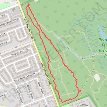
Upper Terrace Trails
- Distance: 2.9 Km
- Elevation gain: 23 m
- Maximum elevation: 155 m
- Elevation loss: 23 m
- Minimum elevation: 139 m
- Moving time: 1 h 5 m
- Moving speed: 2.6 Km/h
- Maximum speed: 13.0 Km/h
- Total time: 1 h 13 m
- Global speed: 2.4 Km/h
Interactive trail map
Thank you for supporting this site ❤️
Make a donation
Make a donation
Gear up for your next adventure:
As an Amazon Associate, this site earns from qualifying purchases at no extra cost to you.
Trail profile
- Distance: 2.9 Km
- Elevation gain: 23 m
- Maximum elevation: 155 m
- Elevation loss: 23 m
- Minimum elevation: 139 m
- Moving time: 1 h 5 m
- Moving speed: 2.6 Km/h
- Maximum speed: 13.0 Km/h
- Total time: 1 h 13 m
- Global speed: 2.4 Km/h
Thank you for supporting this site ❤️
Make a donation
Make a donation
Gear up for your next adventure:
As an Amazon Associate, this site earns from qualifying purchases at no extra cost to you.
About this trail
Name: Upper Terrace Trails trail, distance, elevation, map, profile, GPS track
Coordinates: 45.88425 -77.25126 45.89408 -77.24342
Topography: Renfrew County topographic map, elevation, terrain
Thank you for supporting this site ❤️
Make a donation
Make a donation
Gear up for your next adventure:
As an Amazon Associate, this site earns from qualifying purchases at no extra cost to you.
Other hiking, mountain biking, running and outdoor activity trails
Click on a trail to view its statistics, map and profile.