Thank you for supporting this site ❤️
Make a donation
Make a donation
Gear up for your next adventure:
As an Amazon Associate, this site earns from qualifying purchases at no extra cost to you.
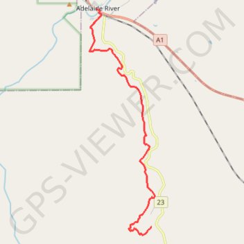
Adelaide River - Robin Falls
- Distance: 19.4 Km
- Elevation gain: 371 m
- Maximum elevation: 215 m
- Elevation loss: 346 m
- Minimum elevation: 46 m
Interactive trail map
Thank you for supporting this site ❤️
Make a donation
Make a donation
Gear up for your next adventure:
As an Amazon Associate, this site earns from qualifying purchases at no extra cost to you.
Trail profile
- Distance: 19.4 Km
- Elevation gain: 371 m
- Maximum elevation: 215 m
- Elevation loss: 346 m
- Minimum elevation: 46 m
Thank you for supporting this site ❤️
Make a donation
Make a donation
Gear up for your next adventure:
As an Amazon Associate, this site earns from qualifying purchases at no extra cost to you.
About this trail
Name: Adelaide River - Robin Falls trail, distance, elevation, map, profile, GPS track
End: Robin Falls Road, Robin Falls, Coomalie Shire, Northern Territory, Australia (-13.35080 131.13534)
Coordinates: -13.35462 131.10281 -13.23927 131.13694
Thank you for supporting this site ❤️
Make a donation
Make a donation
Gear up for your next adventure:
As an Amazon Associate, this site earns from qualifying purchases at no extra cost to you.
Other hiking, mountain biking, running and outdoor activity trails
Click on a trail to view its statistics, map and profile.
Robin Falls Trail
Distance: 11.8 Km • Elevation gain: 339 m • Maximum elevation: 216 m