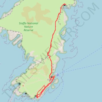
Staffa National Nature Reserve
- Distance: 1.9 Km
- Elevation gain: 30 m
- Maximum elevation: 17 m
- Elevation loss: 27 m
- Minimum elevation: 1 m
Interactive trail map
Trail profile
- Distance: 1.9 Km
- Elevation gain: 30 m
- Maximum elevation: 17 m
- Elevation loss: 27 m
- Minimum elevation: 1 m
About this trail
Name: Staffa National Nature Reserve trail, distance, elevation, map, profile, GPS track
Start: Clamshell Cave, Argyll and Bute, Scotland, United Kingdom (56.43270 -6.33926)
End: Clamshell Cave, Argyll and Bute, Scotland, United Kingdom (56.43263 -6.33953)
Coordinates: 56.43135 -6.34137 56.43722 -6.33795