Thank you for supporting this site ❤️
Make a donation
Make a donation
Gear up for your next adventure:
As an Amazon Associate, this site earns from qualifying purchases at no extra cost to you.
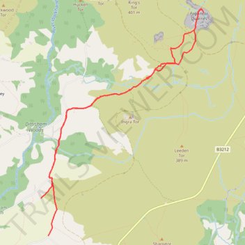
Foggintor Quarries in Dartmoor National Park
- Distance: 9.4 Km
- Elevation gain: 302 m
- Maximum elevation: 396 m
- Elevation loss: 273 m
- Minimum elevation: 181 m
- Moving time: 2 h 22 m
- Moving speed: 4.0 Km/h
- Maximum speed: 6.2 Km/h
- Total time: 2 h 37 m
- Global speed: 3.6 Km/h
Interactive trail map
Thank you for supporting this site ❤️
Make a donation
Make a donation
Gear up for your next adventure:
As an Amazon Associate, this site earns from qualifying purchases at no extra cost to you.
Trail profile
- Distance: 9.4 Km
- Elevation gain: 302 m
- Maximum elevation: 396 m
- Elevation loss: 273 m
- Minimum elevation: 181 m
- Moving time: 2 h 22 m
- Moving speed: 4.0 Km/h
- Maximum speed: 6.2 Km/h
- Total time: 2 h 37 m
- Global speed: 3.6 Km/h
Thank you for supporting this site ❤️
Make a donation
Make a donation
Gear up for your next adventure:
As an Amazon Associate, this site earns from qualifying purchases at no extra cost to you.
About this trail
Name: Foggintor Quarries in Dartmoor National Park trail, distance, elevation, map, profile, GPS track
Coordinates: 50.51549 -4.05801 50.54523 -4.02441
Thank you for supporting this site ❤️
Make a donation
Make a donation
Gear up for your next adventure:
As an Amazon Associate, this site earns from qualifying purchases at no extra cost to you.