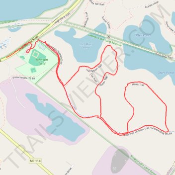
Sebago Lake Land Reserve loop trails
- Distance: 4.0 Km
- Elevation gain: 24 m
- Maximum elevation: 101 m
- Elevation loss: 28 m
- Minimum elevation: 83 m
- Moving time: 54 m 38 s
- Moving speed: 4.4 Km/h
- Maximum speed: 38.8 Km/h
- Total time: 1 h 3 m
- Global speed: 3.7 Km/h
Interactive trail map
Trail profile
- Distance: 4.0 Km
- Elevation gain: 24 m
- Maximum elevation: 101 m
- Elevation loss: 28 m
- Minimum elevation: 83 m
- Moving time: 54 m 38 s
- Moving speed: 4.4 Km/h
- Maximum speed: 38.8 Km/h
- Total time: 1 h 3 m
- Global speed: 3.7 Km/h
About this trail
Name: Sebago Lake Land Reserve loop trails trail, distance, elevation, map, profile, GPS track
Coordinates: 43.75726 -70.51902 43.76257 -70.50660