Thank you for supporting this site ❤️
Make a donation
Make a donation
Gear up for your next adventure:
As an Amazon Associate, this site earns from qualifying purchases at no extra cost to you.
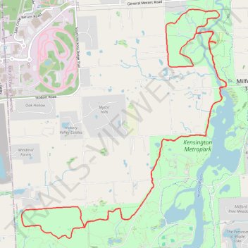
Kensington Metropark
- Distance: 20.1 Km
- Elevation gain: 201 m
- Maximum elevation: 326 m
- Elevation loss: 200 m
- Minimum elevation: 269 m
Interactive trail map
Thank you for supporting this site ❤️
Make a donation
Make a donation
Gear up for your next adventure:
As an Amazon Associate, this site earns from qualifying purchases at no extra cost to you.
Trail profile
- Distance: 20.1 Km
- Elevation gain: 201 m
- Maximum elevation: 326 m
- Elevation loss: 200 m
- Minimum elevation: 269 m
Thank you for supporting this site ❤️
Make a donation
Make a donation
Gear up for your next adventure:
As an Amazon Associate, this site earns from qualifying purchases at no extra cost to you.
About this trail
Name: Kensington Metropark trail, distance, elevation, map, profile, GPS track
Coordinates: 42.54005 -83.67092 42.57742 -83.62563
Thank you for supporting this site ❤️
Make a donation
Make a donation
Gear up for your next adventure:
As an Amazon Associate, this site earns from qualifying purchases at no extra cost to you.