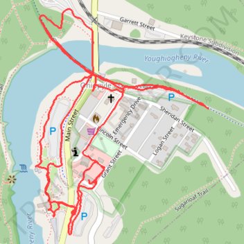
Around Town Ohiopyle
- Distance: 4.2 Km
- Elevation gain: 70 m
- Maximum elevation: 386 m
- Elevation loss: 64 m
- Minimum elevation: 362 m
- Moving time: 53 m 37 s
- Moving speed: 4.7 Km/h
- Maximum speed: 7.0 Km/h
- Total time: 1 h 2 m
- Global speed: 4.1 Km/h
Interactive trail map
Trail profile
- Distance: 4.2 Km
- Elevation gain: 70 m
- Maximum elevation: 386 m
- Elevation loss: 64 m
- Minimum elevation: 362 m
- Moving time: 53 m 37 s
- Moving speed: 4.7 Km/h
- Maximum speed: 7.0 Km/h
- Total time: 1 h 2 m
- Global speed: 4.1 Km/h
About this trail
Name: Around Town Ohiopyle trail, distance, elevation, map, profile, GPS track
Coordinates: 39.86600 -79.49499 39.87192 -79.48907