Make a donation
Gear up for your next adventure:
As an Amazon Associate, this site earns from qualifying purchases at no extra cost to you.
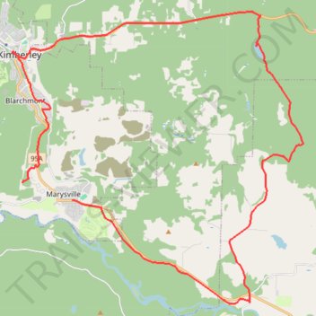
Mcginty Lake Loop
- Distance: 39.1 Km
- Elevation gain: 392 m
- Maximum elevation: 1,129 m
- Elevation loss: 472 m
- Minimum elevation: 884 m
- Moving time: 2 h 30 m
- Moving speed: 15.6 Km/h
- Maximum speed: 48.6 Km/h
- Total time: 3 h 11 m
- Global speed: 12.2 Km/h
Interactive trail map
Make a donation
Gear up for your next adventure:
As an Amazon Associate, this site earns from qualifying purchases at no extra cost to you.
Trail profile
- Distance: 39.1 Km
- Elevation gain: 392 m
- Maximum elevation: 1,129 m
- Elevation loss: 472 m
- Minimum elevation: 884 m
- Moving time: 2 h 30 m
- Moving speed: 15.6 Km/h
- Maximum speed: 48.6 Km/h
- Total time: 3 h 11 m
- Global speed: 12.2 Km/h
Make a donation
Gear up for your next adventure:
As an Amazon Associate, this site earns from qualifying purchases at no extra cost to you.
About this trail
Name: Mcginty Lake Loop trail, distance, elevation, map, profile, GPS track
Coordinates: 49.60209 -115.98536 49.69927 -115.83583
Topography: Kimberley topographic map, elevation, terrain
Make a donation
Gear up for your next adventure:
As an Amazon Associate, this site earns from qualifying purchases at no extra cost to you.
Other hiking, mountain biking, running and outdoor activity trails
Click on a trail to view its statistics, map and profile.
Bike Trails in Kimberley
Canada > British Columbia > Regional District of East Kootenay > Kimberley
Tour through the forest
Distance: 12.4 Km • Elevation gain: 302 m • Maximum elevation: 1,228 m
Dipper Lake/Horsebarn Nature Park Trail
Canada > British Columbia > Regional District of East Kootenay > Kimberley
Bike, trails, kimberley
Distance: 18.9 Km • Elevation gain: 578 m • Maximum elevation: 1,342 m
Make a donation
Gear up for your next adventure:
As an Amazon Associate, this site earns from qualifying purchases at no extra cost to you.
Mountain Bike trail near Kimberley
Canada > British Columbia > Regional District of East Kootenay > Kimberley
Distance: 25.5 Km • Elevation gain: 673 m • Maximum elevation: 1,154 m
Bike trail near Kimberley
Canada > British Columbia > Regional District of East Kootenay > Kimberley
Bike, trails, kimberley
Distance: 10.7 Km • Elevation gain: 208 m • Maximum elevation: 1,160 m
Bike Trails in Kimberley
Canada > British Columbia > Regional District of East Kootenay > Kimberley
Bike, Trails, Kimberley
Distance: 21.5 Km • Elevation gain: 554 m • Maximum elevation: 1,364 m
Bike trail near Kimberley
Canada > British Columbia > Regional District of East Kootenay > Kimberley
Distance: 15.7 Km • Elevation gain: 451 m • Maximum elevation: 1,381 m
Make a donation
Gear up for your next adventure:
As an Amazon Associate, this site earns from qualifying purchases at no extra cost to you.
Rails to Trails
Canada > British Columbia > Regional District of East Kootenay > Kimberley
Bike, Trails, Kimberley
Distance: 19.4 Km • Elevation gain: 247 m • Maximum elevation: 1,039 m
Marks Creek trail
Canada > British Columbia > Regional District of East Kootenay > Kimberley
Little ride in the afternoon
Distance: 12.9 Km • Elevation gain: 203 m • Maximum elevation: 1,064 m