
Little Falls Trail in Little River Canyon National Preserve
The Little Falls Trail is a captivating short hike that leads to a peaceful, scenic spot. Along the route, hikers are treated to views of the river and canyon, with the highlight being Little Falls itself, a gentle cascade flowing over sandstone ledges. The surrounding forest offers a quiet escape, with diverse plant and wildlife, making this trail an enjoyable and serene choice for those seeking a quick immersion into the natural beauty of the preserve. #Hiking #Waterfall #River #Canyon #Forest #Nature
- Distance: 2.5 Km
- Elevation gain: 58 m
- Maximum elevation: 372 m
- Elevation loss: 57 m
- Minimum elevation: 338 m
- Moving time: 52 m 41 s
- Moving speed: 2.8 Km/h
- Maximum speed: 5.7 Km/h
- Total time: 1 h 6 m
- Global speed: 2.3 Km/h
Interactive trail map
Trail profile
- Distance: 2.5 Km
- Elevation gain: 58 m
- Maximum elevation: 372 m
- Elevation loss: 57 m
- Minimum elevation: 338 m
- Moving time: 52 m 41 s
- Moving speed: 2.8 Km/h
- Maximum speed: 5.7 Km/h
- Total time: 1 h 6 m
- Global speed: 2.3 Km/h
About this trail
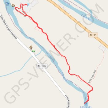
Name: Little Falls Trail in Little River Canyon National Preserve trail, distance, elevation, map, profile, GPS track
Start: Little River Falls Boardwalk, Cherokee County, Alabama, United States (34.39518 -85.62552)
End: Little River Falls Boardwalk, Cherokee County, Alabama, United States (34.39509 -85.62536)
Coordinates: 34.38783 -85.62651 34.39518 -85.61959