Bear Mountain Loop via Hessian Lake, Major Welch Trail, Perkins Memorial Tower and Appalachian Trail in Bear Mountain State Park
The Bear Mountain Loop offers an invigorating hike through diverse landscapes. Starting from the serene Hessian Lake, hikers will enjoy tranquil reflections of the surrounding nature before facing the rugged inclines of the Major Welch Trail, where stunning views of the Hudson River and Bear Mountain Bridge emerge as rewards for their efforts. The route culminates at Perkins Memorial Tower, providing panoramic vistas that stretch as far as the NYC skyline on clear days, making it a perfect spot to take in the beauty of the Hudson Valley.
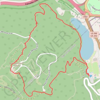
- Distance: 6.3 Km
- Elevation gain: 365 m
- Maximum elevation: 392 m
- Elevation loss: 365 m
- Minimum elevation: 59 m
- Moving time: 1 h 58 m
- Moving speed: 3.2 Km/h
- Maximum speed: 7.5 Km/h
- Total time: 2 h 12 m
- Global speed: 2.9 Km/h
Interactive trail map
Trail profile
- Distance: 6.3 Km
- Elevation gain: 365 m
- Maximum elevation: 392 m
- Elevation loss: 365 m
- Minimum elevation: 59 m
- Moving time: 1 h 58 m
- Moving speed: 3.2 Km/h
- Maximum speed: 7.5 Km/h
- Total time: 2 h 12 m
- Global speed: 2.9 Km/h
About this trail
Name: Bear Mountain Loop via Hessian Lake, Major Welch Trail, Perkins Memorial Tower and Appalachian Trail in Bear Mountain State Park trail, distance, elevation, map, profile, GPS track
Coordinates: 41.30736 -74.00733 41.32185 -73.99098
Other hiking, mountain biking, running and outdoor activity trails
Click on a trail to view its statistics, map and profile.