Camelback Mountain via Cholla Trail in Echo Canyon Recreation Area
The Cholla Trail to the summit of Camelback Mountain offers a captivating yet demanding hiking experience, with diverse terrain ranging from gentle slopes to challenging rock scrambles as you approach the peak. The trail provides stunning views of the Phoenix cityscape and surrounding desert landscapes, particularly from the summit, where hikers are treated to panoramic vistas of the city and distant mountain ranges. While the route can be strenuous, particularly in the final stretch, the trail rewards hikers with a sense of accomplishment and the opportunity to witness Arizona's rugged beauty from one of the region's most iconic peaks. #Hiking #Mountain #Rock #City #Desert #Nature
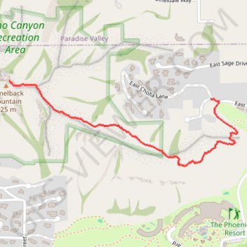
- Distance: 2.2 Km
- Elevation gain: 360 m
- Maximum elevation: 792 m
- Elevation loss: 16 m
- Minimum elevation: 446 m
Interactive trail map
Trail profile
- Distance: 2.2 Km
- Elevation gain: 360 m
- Maximum elevation: 792 m
- Elevation loss: 16 m
- Minimum elevation: 446 m
About this trail
Name: Camelback Mountain via Cholla Trail in Echo Canyon Recreation Area trail, distance, elevation, map, profile, GPS track
End: Cholla Trail, Phoenix, Maricopa County, Arizona, 85018, United States (33.51468 -111.96164)
Coordinates: 33.51019 -111.96164 33.51468 -111.94726
Other hiking, mountain biking, running and outdoor activity trails
Click on a trail to view its statistics, map and profile.
Echo Canyon Trail to Camelback Mountain in Echo Canyon Recreation Area
United States > Arizona > Maricopa County > Phoenix
The trail is strenuous, with steep inclines and a fun rock scramble near the summit, so sturdy footwear and plenty of water are essential. Though challenging, the breathtaking views of Phoenix and the incredible panorama at the top make it a hike worth every step. #Hiking #Mountain #City #Nature
Distance: 3.7 Km • Elevation gain: 376 m • Maximum elevation: 797 m