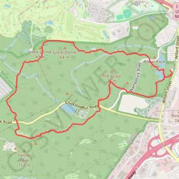
Skyline Trail, Sawcut Notch Path and Headquarters Path Loop in Blue Hills Reservation
This loop offers a diverse hiking experience with a blend of rocky ascents, shaded woods, and stunning vistas. Hikers can enjoy panoramic views of the Boston skyline from various points along the route, particularly from Nahanton Hill, while also passing serene spots like Saint Moritz Pond. This loop presents both a challenge and a rewarding escape into nature, making it ideal for those looking to experience the area's rugged beauty. #Hiking #Loop #Overlook #Lake #Forest #Nature
- Distance: 8.7 Km
- Elevation gain: 166 m
- Maximum elevation: 138 m
- Elevation loss: 167 m
- Minimum elevation: 30 m
- Moving time: 2 h 7 m
- Moving speed: 4.1 Km/h
- Maximum speed: 13.0 Km/h
- Total time: 2 h 10 m
- Global speed: 4.0 Km/h
Interactive trail map
Trail profile
- Distance: 8.7 Km
- Elevation gain: 166 m
- Maximum elevation: 138 m
- Elevation loss: 167 m
- Minimum elevation: 30 m
- Moving time: 2 h 7 m
- Moving speed: 4.1 Km/h
- Maximum speed: 13.0 Km/h
- Total time: 2 h 10 m
- Global speed: 4.0 Km/h
About this trail
Name: Skyline Trail, Sawcut Notch Path and Headquarters Path Loop in Blue Hills Reservation trail, distance, elevation, map, profile, GPS track
Start: Willard Street, Quincy, Norfolk County, Massachusetts, 02269, United States (42.23417 -71.02961)
End: Willard Street, Quincy, Norfolk County, Massachusetts, 02269, United States (42.23373 -71.02925)
Coordinates: 42.22376 -71.06333 42.23866 -71.02925