Make a donation
Gear up for your next adventure:
As an Amazon Associate, this site earns from qualifying purchases at no extra cost to you.
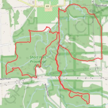
Shorthills trails perimeter watch trace
Thorold Running
- Distance: 17.2 Km
- Elevation gain: 285 m
- Maximum elevation: 169 m
- Elevation loss: 285 m
- Minimum elevation: 97 m
- Moving time: 1 h 48 m
- Moving speed: 9.5 Km/h
- Maximum speed: 24.8 Km/h
- Total time: 1 h 49 m
- Global speed: 9.4 Km/h
Interactive trail map
Make a donation
Gear up for your next adventure:
As an Amazon Associate, this site earns from qualifying purchases at no extra cost to you.
Trail profile
- Distance: 17.2 Km
- Elevation gain: 285 m
- Maximum elevation: 169 m
- Elevation loss: 285 m
- Minimum elevation: 97 m
- Moving time: 1 h 48 m
- Moving speed: 9.5 Km/h
- Maximum speed: 24.8 Km/h
- Total time: 1 h 49 m
- Global speed: 9.4 Km/h
Make a donation
Gear up for your next adventure:
As an Amazon Associate, this site earns from qualifying purchases at no extra cost to you.
About this trail
Name: Shorthills trails perimeter watch trace trail, distance, elevation, map, profile, GPS track
Coordinates: 43.08348 -79.30572 43.10912 -79.27191
Topography: Niagara Region topographic map, elevation, terrain
Make a donation
Gear up for your next adventure:
As an Amazon Associate, this site earns from qualifying purchases at no extra cost to you.
Other hiking, mountain biking, running and outdoor activity trails
Click on a trail to view its statistics, map and profile.
Niagara Falls - Hamilton
Canada > Ontario > Niagara Region > Niagara Falls
#Bike
Distance: 84.1 Km • Elevation gain: 537 m • Maximum elevation: 209 m