Ramon and Lotz
הר רמון ולוץ: בורות לוץ ומעלה לוץ
- Distance: 26.7 Km
- Elevation gain: 578 m
- Maximum elevation: 1,030 m
- Elevation loss: 576 m
- Minimum elevation: 816 m
- Moving time: 7 h 22 m
- Moving speed: 3.6 Km/h
- Maximum speed: 4.0 Km/h
- Total time: 7 h 22 m
- Global speed: 3.6 Km/h
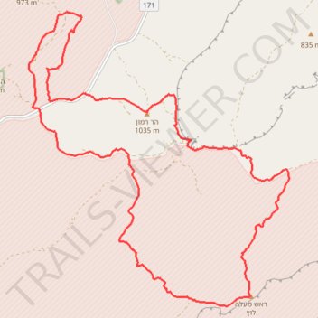
Interactive trail map
Trail profile
- Distance: 26.7 Km
- Elevation gain: 578 m
- Maximum elevation: 1,030 m
- Elevation loss: 576 m
- Minimum elevation: 816 m
- Moving time: 7 h 22 m
- Moving speed: 3.6 Km/h
- Maximum speed: 4.0 Km/h
- Total time: 7 h 22 m
- Global speed: 3.6 Km/h
About this trail
Name: Ramon and Lotz trail, distance, elevation, map, profile, GPS track
Start: 171, Ramat Negev Regional Council, Beersheba Subdistrict, South District, Israel (30.51332 34.60850)
End: 171, Ramat Negev Regional Council, Beersheba Subdistrict, South District, Israel (30.51315 34.60826)
Coordinates: 30.46229 34.60751 30.52337 34.67016
Other hiking, mountain biking, running and outdoor activity trails
Click on a trail to view its statistics, map and profile.
Mount Ramon - Mount Arif
Israel > South District > Ramat Negev Regional Council
הר רמון להר עריף: הכי רחוק מציוויליזציה וארוך מספיק לזקק
Distance: 42.9 Km • Elevation gain: 1,159 m • Maximum elevation: 1,030 m
Mount Ramon and Mount Ido
Israel > South District > Ramat Negev Regional Council
הר רמון והר עידו מעלה: הפריזמות ומעלה ערוד באזור הכי על-הירח שיש
Distance: 19.6 Km • Elevation gain: 667 m • Maximum elevation: 1,030 m