Thank you for supporting this site ❤️
Make a donation
Make a donation
Gear up for your next adventure:
As an Amazon Associate, this site earns from qualifying purchases at no extra cost to you.
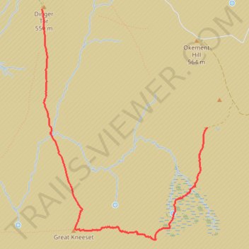
Dinger Tor to Ockerton Court via Great Kneeset
- Distance: 4.8 Km
- Elevation gain: 130 m
- Maximum elevation: 568 m
- Elevation loss: 118 m
- Minimum elevation: 472 m
- Moving time: 1 h 39 m
- Moving speed: 2.9 Km/h
- Maximum speed: 10.0 Km/h
- Total time: 2 h 18 m
- Global speed: 2.1 Km/h
Interactive trail map
Thank you for supporting this site ❤️
Make a donation
Make a donation
Gear up for your next adventure:
As an Amazon Associate, this site earns from qualifying purchases at no extra cost to you.
Trail profile
- Distance: 4.8 Km
- Elevation gain: 130 m
- Maximum elevation: 568 m
- Elevation loss: 118 m
- Minimum elevation: 472 m
- Moving time: 1 h 39 m
- Moving speed: 2.9 Km/h
- Maximum speed: 10.0 Km/h
- Total time: 2 h 18 m
- Global speed: 2.1 Km/h
Thank you for supporting this site ❤️
Make a donation
Make a donation
Gear up for your next adventure:
As an Amazon Associate, this site earns from qualifying purchases at no extra cost to you.
About this trail
Name: Dinger Tor to Ockerton Court via Great Kneeset trail, distance, elevation, map, profile, GPS track
End: Okement Hill Road, Dartmoor Forest, West Devon, Devon, England, United Kingdom (50.66454 -3.97877)
Coordinates: 50.65439 -4.00227 50.67519 -3.97878
Thank you for supporting this site ❤️
Make a donation
Make a donation
Gear up for your next adventure:
As an Amazon Associate, this site earns from qualifying purchases at no extra cost to you.