Thank you for supporting this site ❤️
Make a donation
Make a donation
Gear up for your next adventure:
As an Amazon Associate, this site earns from qualifying purchases at no extra cost to you.
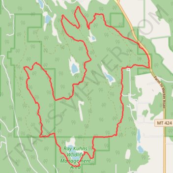
Pig Trail System
- Distance: 20.8 Km
- Elevation gain: 474 m
- Maximum elevation: 1,154 m
- Elevation loss: 474 m
- Minimum elevation: 932 m
- Moving time: 4 h 28 m
- Moving speed: 4.7 Km/h
- Maximum speed: 7.9 Km/h
- Total time: 4 h 47 m
- Global speed: 4.3 Km/h
Interactive trail map
Thank you for supporting this site ❤️
Make a donation
Make a donation
Gear up for your next adventure:
As an Amazon Associate, this site earns from qualifying purchases at no extra cost to you.
Trail profile
- Distance: 20.8 Km
- Elevation gain: 474 m
- Maximum elevation: 1,154 m
- Elevation loss: 474 m
- Minimum elevation: 932 m
- Moving time: 4 h 28 m
- Moving speed: 4.7 Km/h
- Maximum speed: 7.9 Km/h
- Total time: 4 h 47 m
- Global speed: 4.3 Km/h
Thank you for supporting this site ❤️
Make a donation
Make a donation
Gear up for your next adventure:
As an Amazon Associate, this site earns from qualifying purchases at no extra cost to you.
About this trail
Name: Pig Trail System trail, distance, elevation, map, profile, GPS track
Start: 1, Farm To Market Road, Flathead County, Montana, United States (48.33111 -114.42359)
End: 1, Farm To Market Road, Flathead County, Montana, United States (48.33110 -114.42345)
Coordinates: 48.30498 -114.47303 48.34725 -114.42318
Thank you for supporting this site ❤️
Make a donation
Make a donation
Gear up for your next adventure:
As an Amazon Associate, this site earns from qualifying purchases at no extra cost to you.