Thank you for supporting this site ❤️
Make a donation
Make a donation
Gear up for your next adventure:
As an Amazon Associate, this site earns from qualifying purchases at no extra cost to you.
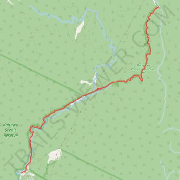
2023-04-15_12-41_Sat
- Distance: 15.4 Km
- Elevation gain: 568 m
- Maximum elevation: 266 m
- Elevation loss: 568 m
- Minimum elevation: 125 m
- Moving time: 3 h 22 m
- Moving speed: 4.6 Km/h
- Maximum speed: 7.8 Km/h
- Total time: 3 h 55 m
- Global speed: 3.9 Km/h
Interactive trail map
Thank you for supporting this site ❤️
Make a donation
Make a donation
Gear up for your next adventure:
As an Amazon Associate, this site earns from qualifying purchases at no extra cost to you.
Trail profile
- Distance: 15.4 Km
- Elevation gain: 568 m
- Maximum elevation: 266 m
- Elevation loss: 568 m
- Minimum elevation: 125 m
- Moving time: 3 h 22 m
- Moving speed: 4.6 Km/h
- Maximum speed: 7.8 Km/h
- Total time: 3 h 55 m
- Global speed: 3.9 Km/h
Thank you for supporting this site ❤️
Make a donation
Make a donation
Gear up for your next adventure:
As an Amazon Associate, this site earns from qualifying purchases at no extra cost to you.
About this trail
Name: 2023-04-15_12-41_Sat trail, distance, elevation, map, profile, GPS track
Coordinates: -40.87734 175.13225 -40.84011 175.17261
Thank you for supporting this site ❤️
Make a donation
Make a donation
Gear up for your next adventure:
As an Amazon Associate, this site earns from qualifying purchases at no extra cost to you.