Mount Bierstadt Trail in Mount Evans Wilderness
The Mount Bierstadt Trail offers a fantastic opportunity to summit one of Colorado's iconic 14ers with relatively moderate difficulty. Starting from the Guanella Pass Trailhead, the route takes hikers through alpine meadows, crossing wooden bridges over Scott Gomer Creek, and gradually ascending toward the base of the mountain. As you climb, the scenery evolves, showcasing sweeping views of the rugged Sawtooth Ridge and the expansive Front Range before reaching the rocky summit, where panoramic vistas stretch over the surrounding peaks, including Mount Blue Sky (formerly Mount Evans). #Hiking #Mountain #Forest #Nature
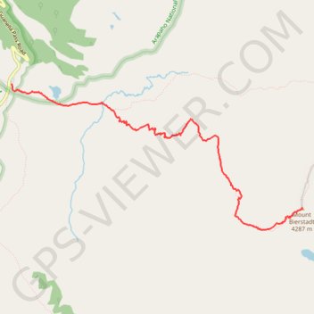
- Distance: 5.9 Km
- Elevation gain: 777 m
- Maximum elevation: 4,278 m
- Elevation loss: 49 m
- Minimum elevation: 3,505 m
Interactive trail map
Trail profile
- Distance: 5.9 Km
- Elevation gain: 777 m
- Maximum elevation: 4,278 m
- Elevation loss: 49 m
- Minimum elevation: 3,505 m
About this trail
Name: Mount Bierstadt Trail in Mount Evans Wilderness trail, distance, elevation, map, profile, GPS track
Start: Mount Bierstadt Trail, Clear Creek County, Colorado, United States (39.59632 -105.71020)
End: Mount Bierstadt Trail, Clear Creek County, Colorado, United States (39.58265 -105.66869)
Coordinates: 39.58022 -105.71021 39.59632 -105.66869
Other hiking, mountain biking, running and outdoor activity trails
Click on a trail to view its statistics, map and profile.
Mount Bierstadt in Mount Evans Wilderness
United States > Colorado > Clear Creek County
The Mount Bierstadt trail takes you through the stunning alpine landscape of the Mount Blue Sky wilderness area, where you'll experience a steady ascent that keeps you on your toes. As you climb, the air grows thinner, and the breathtaking views of the Front Range. Though the hike becomes increasingly…
Distance: 11.6 Km • Elevation gain: 816 m • Maximum elevation: 4,279 m