Make a donation
Gear up for your next adventure:
As an Amazon Associate, this site earns from qualifying purchases at no extra cost to you.
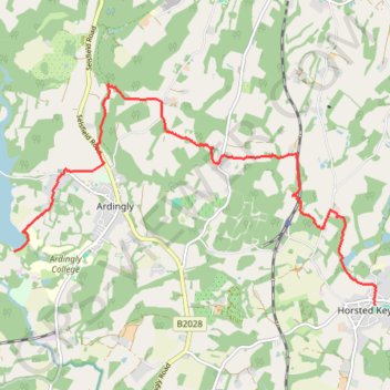
Walk - Ardingly Reservoir, Horsted Keynes
- Distance: 10.7 Km
- Elevation gain: 284 m
- Maximum elevation: 133 m
- Elevation loss: 243 m
- Minimum elevation: 52 m
- Moving time: 2 h 17 m
- Moving speed: 4.7 Km/h
- Maximum speed: 6.9 Km/h
- Total time: 2 h 27 m
- Global speed: 4.3 Km/h
Interactive trail map
Make a donation
Gear up for your next adventure:
As an Amazon Associate, this site earns from qualifying purchases at no extra cost to you.
Trail profile
- Distance: 10.7 Km
- Elevation gain: 284 m
- Maximum elevation: 133 m
- Elevation loss: 243 m
- Minimum elevation: 52 m
- Moving time: 2 h 17 m
- Moving speed: 4.7 Km/h
- Maximum speed: 6.9 Km/h
- Total time: 2 h 27 m
- Global speed: 4.3 Km/h
Make a donation
Gear up for your next adventure:
As an Amazon Associate, this site earns from qualifying purchases at no extra cost to you.
About this trail
Name: Walk - Ardingly Reservoir, Horsted Keynes trail, distance, elevation, map, profile, GPS track
Start: North Quad, Ardingly, Mid Sussex, West Sussex, England, RH17 6SQ, United Kingdom (51.04276 -0.09868)
Coordinates: 51.03605 -0.09868 51.06337 -0.02752
Make a donation
Gear up for your next adventure:
As an Amazon Associate, this site earns from qualifying purchases at no extra cost to you.
Other hiking, mountain biking, running and outdoor activity trails
Click on a trail to view its statistics, map and profile.
Loop walk around Balcome including Ardingly Reservoir
United Kingdom > England > West Sussex > Mid Sussex > Balcombe
Balcombe, West Sussex, UK
Distance: 11.0 Km • Elevation gain: 192 m • Maximum elevation: 106 m
Ardingly Reservoir to Wakehurst Place walk
United Kingdom > England > West Sussex > Mid Sussex > Ardingly
Distance: 8.1 Km • Elevation gain: 102 m • Maximum elevation: 141 m
Loop Walk between Scaynes Hill and Horsted Keynes
United Kingdom > England > West Sussex > Mid Sussex > Scaynes Hill
Distance: 18.2 Km • Elevation gain: 256 m • Maximum elevation: 100 m
Make a donation
Gear up for your next adventure:
As an Amazon Associate, this site earns from qualifying purchases at no extra cost to you.
Loop walk - Ardingly Reservoir, Balcombe, Wakehurst Place, Ardingly
United Kingdom > England > West Sussex > Mid Sussex > Ardingly
Distance: 16.7 Km • Elevation gain: 329 m • Maximum elevation: 142 m
Loop walk via Ardingly Reservoir, Wakehurst Place and Balcombe
United Kingdom > England > West Sussex > Mid Sussex > Ardingly
Distance: 14.7 Km • Elevation gain: 232 m • Maximum elevation: 139 m
Walk - Ardingly Reservoir, Balcombe, Wakehurst Place
United Kingdom > England > West Sussex > Mid Sussex > Ardingly
Ardingly Reservoir, Balcombe, Wakehurst Place
Distance: 14.7 Km • Elevation gain: 308 m • Maximum elevation: 141 m
Walk - Horsted Keynes, Danehill, Heaven Farm
United Kingdom > England > West Sussex > Mid Sussex > Horsted Keynes
Distance: 13.1 Km • Elevation gain: 282 m • Maximum elevation: 125 m
Make a donation
Gear up for your next adventure:
As an Amazon Associate, this site earns from qualifying purchases at no extra cost to you.
Walk - Ardingly, West Hoathly, Horsted Keynes
United Kingdom > England > West Sussex > Mid Sussex > Ardingly
Distance: 18.9 Km • Elevation gain: 408 m • Maximum elevation: 182 m
Loop Walk - Scaynes Hill, Horsted Keynes
United Kingdom > England > West Sussex > Mid Sussex > Scaynes Hill
Distance: 17.9 Km • Elevation gain: 257 m • Maximum elevation: 100 m
Walk - Balcombe, Ouse Valley, Ardingly
United Kingdom > England > West Sussex > Mid Sussex > Balcombe
Distance: 17.8 Km • Elevation gain: 304 m • Maximum elevation: 130 m
Ardingly to Horsted Keynes Loop Walk
United Kingdom > England > West Sussex > Mid Sussex > Ardingly
Distance: 15.5 Km • Elevation gain: 374 m • Maximum elevation: 134 m
Make a donation
Gear up for your next adventure:
As an Amazon Associate, this site earns from qualifying purchases at no extra cost to you.
Walk - Wakehurst Place, Loder Valley
United Kingdom > England > West Sussex > Mid Sussex > Ardingly
Distance: 7.6 Km • Elevation gain: 137 m • Maximum elevation: 139 m
Walk - Balcombe, Wakehurst, Ardingly
United Kingdom > England > West Sussex > Mid Sussex > Balcombe
Distance: 15.2 Km • Elevation gain: 272 m • Maximum elevation: 140 m
Walk - Scaynes Hill, Horsted Keynes
United Kingdom > England > West Sussex > Mid Sussex > Scaynes Hill
Distance: 17.9 Km • Elevation gain: 259 m • Maximum elevation: 100 m
Ardingly, Horstead Keynes
United Kingdom > England > West Sussex > Mid Sussex > Ardingly
Distance: 18.2 Km • Elevation gain: 373 m • Maximum elevation: 133 m
Make a donation
Gear up for your next adventure:
As an Amazon Associate, this site earns from qualifying purchases at no extra cost to you.
Ardingly Reservoir Dam
United Kingdom > England > West Sussex > Mid Sussex > Horsted Keynes
Distance: 7.7 Km • Elevation gain: 96 m • Maximum elevation: 99 m