Deep Creek Waterfall Loop in Great Smoky Mountains National Park
The Deep Creek Waterfall Loop in Great Smoky Mountains National Park offers hikers a serene journey through lush forests, accompanied by the soothing sounds of flowing water. Along the trail, visitors can observe notable waterfalls, including Juney Whank Falls, Indian Creek Falls, and Tom Branch Falls, each presenting unique cascades amidst verdant surroundings. The path is well-maintained, making it accessible for hikers seeking a tranquil nature experience. #Hiking #Forest #Nature #Loop #Waterfall #Mountain
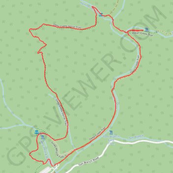
- Distance: 3.9 Km
- Elevation gain: 189 m
- Maximum elevation: 691 m
- Elevation loss: 190 m
- Minimum elevation: 560 m
- Moving time: 1 h 15 m
- Moving speed: 3.1 Km/h
- Maximum speed: 7.8 Km/h
- Total time: 1 h 36 m
- Global speed: 2.4 Km/h
Interactive trail map
Trail profile
- Distance: 3.9 Km
- Elevation gain: 189 m
- Maximum elevation: 691 m
- Elevation loss: 190 m
- Minimum elevation: 560 m
- Moving time: 1 h 15 m
- Moving speed: 3.1 Km/h
- Maximum speed: 7.8 Km/h
- Total time: 1 h 36 m
- Global speed: 2.4 Km/h
About this trail
Name: Deep Creek Waterfall Loop in Great Smoky Mountains National Park trail, distance, elevation, map, profile, GPS track
Coordinates: 35.46457 -83.43583 35.47412 -83.42748
Other hiking, mountain biking, running and outdoor activity trails
Click on a trail to view its statistics, map and profile.
Waterfalls Loop via Deep Creek Trail in Great Smoky Mountains National Park
United States > North Carolina > Swain County > Deep Creek
This Waterfalls Loop via the Deep Creek Trail in the Great Smoky Mountains National Park offers a serene and scenic hiking experience. Along the way, hikers encounter three picturesque waterfalls: Juney Whank Falls, Indian Creek Falls and Tom Branch Falls. Each waterfall has its own charm, with the cascading…
Distance: 3.9 Km • Elevation gain: 188 m • Maximum elevation: 691 m
Great Smoky Mountains Appalachian Trail
United States > North Carolina > Clay County
Hike through Great Smoky Mountains along Appalachian Trail via Standing Indian, Ridgepole Mountain, Yellow Bald, Wine Spring Bald, Copper Ridge Bald, Cheoah Bald, Wauchecha Bald, Fontana Dam, Thunderhead Mountain, Clingmans Dome, Mount Kephart and Mount Guyot. #Hiking #Mountain #Nature #Forest #Lake…
Distance: 231.7 Km • Elevation gain: 8,873 m • Maximum elevation: 2,013 m