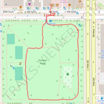
Pioneer Park Loop
- Distance: 0.8 Km
- Elevation gain: 4 m
- Maximum elevation: 1,300 m
- Elevation loss: 4 m
- Minimum elevation: 1,296 m
- Moving time: 9 m 46 s
- Moving speed: 4.7 Km/h
- Maximum speed: 7.2 Km/h
- Total time: 10 m 46 s
- Global speed: 4.2 Km/h
Interactive trail map
Trail profile
- Distance: 0.8 Km
- Elevation gain: 4 m
- Maximum elevation: 1,300 m
- Elevation loss: 4 m
- Minimum elevation: 1,296 m
- Moving time: 9 m 46 s
- Moving speed: 4.7 Km/h
- Maximum speed: 7.2 Km/h
- Total time: 10 m 46 s
- Global speed: 4.2 Km/h
About this trail
Name: Pioneer Park Loop trail, distance, elevation, map, profile, GPS track
Coordinates: 40.76088 -111.90164 40.76306 -111.90005
Other hiking, mountain biking, running and outdoor activity trails
Click on a trail to view its statistics, map and profile.
Bike Ride from Salt Lake City to Woods Cross via Jordan River Parkway
United States > Utah > Salt Lake County > Salt Lake City
Distance: 22.9 Km • Elevation gain: 44 m • Maximum elevation: 1,315 m
Ride from Downtown SLC to Ballpark along 200 S, JRT, and Parleys Trail
United States > Utah > Salt Lake County > Salt Lake City
Distance: 11.7 Km • Elevation gain: 24 m • Maximum elevation: 1,308 m