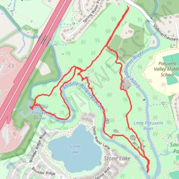
Loop Hike at Savage Park
- Distance: 5.1 Km
- Elevation gain: 90 m
- Maximum elevation: 94 m
- Elevation loss: 90 m
- Minimum elevation: 62 m
- Moving time: 1 h 16 m
- Moving speed: 3.9 Km/h
- Maximum speed: 7.7 Km/h
- Total time: 1 h 19 m
- Global speed: 3.8 Km/h
Interactive trail map
Trail profile
- Distance: 5.1 Km
- Elevation gain: 90 m
- Maximum elevation: 94 m
- Elevation loss: 90 m
- Minimum elevation: 62 m
- Moving time: 1 h 16 m
- Moving speed: 3.9 Km/h
- Maximum speed: 7.7 Km/h
- Total time: 1 h 19 m
- Global speed: 3.8 Km/h
About this trail
Name: Loop Hike at Savage Park trail, distance, elevation, map, profile, GPS track
Coordinates: 39.13805 -76.84353 39.14988 -76.83256
Other hiking, mountain biking, running and outdoor activity trails
Click on a trail to view its statistics, map and profile.
Savage Park
United States > Maryland > Howard County > Savage
Distance: 10.6 Km • Elevation gain: 145 m • Maximum elevation: 105 m