Thank you for supporting this site ❤️
Make a donation
Make a donation
Gear up for your next adventure:
As an Amazon Associate, this site earns from qualifying purchases at no extra cost to you.
Leonard J. Bradley Park loop trails
- Distance: 2.2 Km
- Elevation gain: 21 m
- Maximum elevation: 112 m
- Elevation loss: 21 m
- Minimum elevation: 95 m
- Moving time: 36 m 58 s
- Moving speed: 3.6 Km/h
- Maximum speed: 8.1 Km/h
- Total time: 44 m 45 s
- Global speed: 3.0 Km/h
Interactive trail map
Thank you for supporting this site ❤️
Make a donation
Make a donation
Gear up for your next adventure:
As an Amazon Associate, this site earns from qualifying purchases at no extra cost to you.
Trail profile
- Distance: 2.2 Km
- Elevation gain: 21 m
- Maximum elevation: 112 m
- Elevation loss: 21 m
- Minimum elevation: 95 m
- Moving time: 36 m 58 s
- Moving speed: 3.6 Km/h
- Maximum speed: 8.1 Km/h
- Total time: 44 m 45 s
- Global speed: 3.0 Km/h
Thank you for supporting this site ❤️
Make a donation
Make a donation
Gear up for your next adventure:
As an Amazon Associate, this site earns from qualifying purchases at no extra cost to you.
About this trail
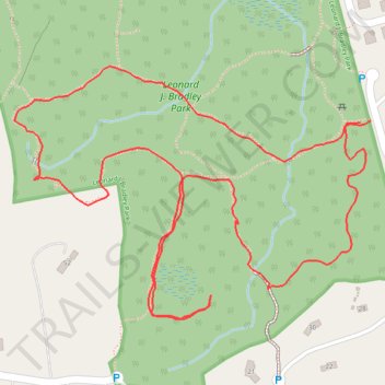
Name: Leonard J. Bradley Park loop trails trail, distance, elevation, map, profile, GPS track
Coordinates: 41.18015 -73.43688 41.18322 -73.43112
Thank you for supporting this site ❤️
Make a donation
Make a donation
Gear up for your next adventure:
As an Amazon Associate, this site earns from qualifying purchases at no extra cost to you.
Other hiking, mountain biking, running and outdoor activity trails
Click on a trail to view its statistics, map and profile.