Thank you for supporting this site ❤️
Make a donation
Make a donation
Gear up for your next adventure:
As an Amazon Associate, this site earns from qualifying purchases at no extra cost to you.
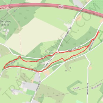
Paths in Queen Down Warren
- Distance: 3.1 Km
- Elevation gain: 60 m
- Maximum elevation: 103 m
- Elevation loss: 58 m
- Minimum elevation: 58 m
- Moving time: 44 m 52 s
- Moving speed: 4.1 Km/h
- Maximum speed: 21.0 Km/h
- Total time: 48 m 31 s
- Global speed: 3.8 Km/h
Interactive trail map
Thank you for supporting this site ❤️
Make a donation
Make a donation
Gear up for your next adventure:
As an Amazon Associate, this site earns from qualifying purchases at no extra cost to you.
Trail profile
- Distance: 3.1 Km
- Elevation gain: 60 m
- Maximum elevation: 103 m
- Elevation loss: 58 m
- Minimum elevation: 58 m
- Moving time: 44 m 52 s
- Moving speed: 4.1 Km/h
- Maximum speed: 21.0 Km/h
- Total time: 48 m 31 s
- Global speed: 3.8 Km/h
Thank you for supporting this site ❤️
Make a donation
Make a donation
Gear up for your next adventure:
As an Amazon Associate, this site earns from qualifying purchases at no extra cost to you.
About this trail
Name: Paths in Queen Down Warren trail, distance, elevation, map, profile, GPS track
Coordinates: 51.33451 0.61314 51.33921 0.63053
Thank you for supporting this site ❤️
Make a donation
Make a donation
Gear up for your next adventure:
As an Amazon Associate, this site earns from qualifying purchases at no extra cost to you.