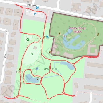
Yad LaBanim Park in Petah Tikva
- Distance: 1.5 Km
- Elevation gain: 12 m
- Maximum elevation: 54 m
- Elevation loss: 14 m
- Minimum elevation: 45 m
- Moving time: 20 m 48 s
- Moving speed: 4.3 Km/h
- Maximum speed: 6.5 Km/h
- Total time: 25 m 49 s
- Global speed: 3.4 Km/h
Interactive trail map
Trail profile
- Distance: 1.5 Km
- Elevation gain: 12 m
- Maximum elevation: 54 m
- Elevation loss: 14 m
- Minimum elevation: 45 m
- Moving time: 20 m 48 s
- Moving speed: 4.3 Km/h
- Maximum speed: 6.5 Km/h
- Total time: 25 m 49 s
- Global speed: 3.4 Km/h
About this trail
Name: Yad LaBanim Park in Petah Tikva trail, distance, elevation, map, profile, GPS track
Coordinates: 32.08587 34.87201 32.08812 34.87464