Thank you for supporting this site ❤️
Make a donation
Make a donation
Gear up for your next adventure:
As an Amazon Associate, this site earns from qualifying purchases at no extra cost to you.
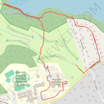
Ponkapoag Pond Dam
- Distance: 8.0 Km
- Elevation gain: 48 m
- Maximum elevation: 74 m
- Elevation loss: 47 m
- Minimum elevation: 44 m
Interactive trail map
Thank you for supporting this site ❤️
Make a donation
Make a donation
Gear up for your next adventure:
As an Amazon Associate, this site earns from qualifying purchases at no extra cost to you.
Trail profile
- Distance: 8.0 Km
- Elevation gain: 48 m
- Maximum elevation: 74 m
- Elevation loss: 47 m
- Minimum elevation: 44 m
Thank you for supporting this site ❤️
Make a donation
Make a donation
Gear up for your next adventure:
As an Amazon Associate, this site earns from qualifying purchases at no extra cost to you.
About this trail
Name: Ponkapoag Pond Dam trail, distance, elevation, map, profile, GPS track
End: 4, Harrison Road, Canton, Norfolk County, Massachusetts, 02021, United States (42.18536 -71.09862)
Coordinates: 42.18215 -71.10751 42.19092 -71.09563
Thank you for supporting this site ❤️
Make a donation
Make a donation
Gear up for your next adventure:
As an Amazon Associate, this site earns from qualifying purchases at no extra cost to you.