Thank you for supporting this site ❤️
Make a donation
Make a donation
Gear up for your next adventure:
As an Amazon Associate, this site earns from qualifying purchases at no extra cost to you.
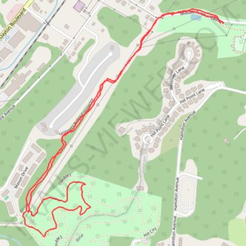
Stringers Ridge Connector
- Distance: 3.8 Km
- Elevation gain: 123 m
- Maximum elevation: 294 m
- Elevation loss: 123 m
- Minimum elevation: 219 m
- Moving time: 50 m 51 s
- Moving speed: 4.5 Km/h
- Maximum speed: 9.6 Km/h
- Total time: 57 m 39 s
- Global speed: 4.0 Km/h
Interactive trail map
Thank you for supporting this site ❤️
Make a donation
Make a donation
Gear up for your next adventure:
As an Amazon Associate, this site earns from qualifying purchases at no extra cost to you.
Trail profile
- Distance: 3.8 Km
- Elevation gain: 123 m
- Maximum elevation: 294 m
- Elevation loss: 123 m
- Minimum elevation: 219 m
- Moving time: 50 m 51 s
- Moving speed: 4.5 Km/h
- Maximum speed: 9.6 Km/h
- Total time: 57 m 39 s
- Global speed: 4.0 Km/h
Thank you for supporting this site ❤️
Make a donation
Make a donation
Gear up for your next adventure:
As an Amazon Associate, this site earns from qualifying purchases at no extra cost to you.
About this trail
Name: Stringers Ridge Connector trail, distance, elevation, map, profile, GPS track
Coordinates: 35.07859 -85.31444 35.08731 -85.30505
Thank you for supporting this site ❤️
Make a donation
Make a donation
Gear up for your next adventure:
As an Amazon Associate, this site earns from qualifying purchases at no extra cost to you.