Import a GPX file

Run along paths in Banstead Common

  • Distance: 5.5 Km
  • Elevation gain: 75 m
  • Maximum elevation: 150 m
  • Elevation loss: 56 m
  • Minimum elevation: 95 m
  • Moving time: 38 m 38 s
  • Moving speed: 8.5 Km/h
  • Maximum speed: 17.2 Km/h
  • Total time: 38 m 38 s
  • Global speed: 8.5 Km/h

Interactive trail map

Trail profile

  • Distance: 5.5 Km
  • Elevation gain: 75 m
  • Maximum elevation: 150 m
  • Elevation loss: 56 m
  • Minimum elevation: 95 m
  • Moving time: 38 m 38 s
  • Moving speed: 8.5 Km/h
  • Maximum speed: 17.2 Km/h
  • Total time: 38 m 38 s
  • Global speed: 8.5 Km/h

About this trail

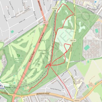
Name: Run along paths in Banstead Common trail, distance, elevation, map, profile, GPS track

Start: Winkworth Road, Nork, Banstead, Reigate and Banstead, Surrey, England, SM7 2QL, United Kingdom (51.32840 -0.20628)

End: Winkworth Road, Banstead, Reigate and Banstead, Surrey, England, SM7 3QN, United Kingdom (51.32736 -0.19509)

Coordinates: 51.32736 -0.20628 51.34284 -0.19449

Gear up for your next adventure:

👟Trail Running Shoes - Agile footwear for fast-paced topographic exploration
Tent Footprint - Protect tent floor and increase durability
🧴Insect Repellent - Protect yourself from bugs during outdoor adventures
🧥Packable Rain Jacket - Breathable waterproof layer for unpredictable weather
🩹Moleskin Blister Pads - Direct protection for painful foot pressure points

As an Amazon Associate, this site earns from qualifying purchases at no extra cost to you.