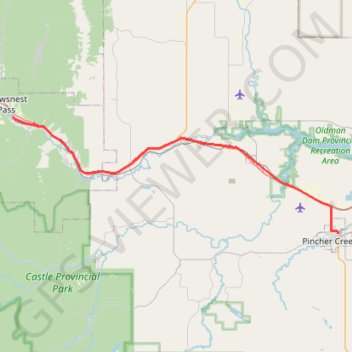
Blairmore - Pincher Creek
#Bike #Blairmore #PincherCreek
- Distance: 47.4 Km
- Elevation gain: 259 m
- Maximum elevation: 1,304 m
- Elevation loss: 436 m
- Minimum elevation: 1,121 m
Interactive trail map
Trail profile
- Distance: 47.4 Km
- Elevation gain: 259 m
- Maximum elevation: 1,304 m
- Elevation loss: 436 m
- Minimum elevation: 1,121 m
About this trail
Name: Blairmore - Pincher Creek trail, distance, elevation, map, profile, GPS track
End: Cowboy Trail, Pincher Creek, Alberta, T0K 1W0, Canada (49.49290 -113.93645)
Coordinates: 49.49290 -114.46166 49.61358 -113.93645
Topography: Alberta topographic map, elevation, terrain
Other hiking, mountain biking, running and outdoor activity trails
Click on a trail to view its statistics, map and profile.
Pincher Creek - Lethbridge
Canada > Alberta > Pincher Creek
#Bike #PincherCreek #Lethbridge
Distance: 101.5 Km • Elevation gain: 228 m • Maximum elevation: 1,146 m