
Cherokee Garden trails
Click on a trail to view its statistics, map and profile.
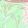
Cherokee Loop
United States > Kentucky > Jefferson County > Louisville > Cherokee Garden
Distance: 2.3 Km • Elevation gain: 26 m • Maximum elevation: 154 m
Click on a trail to view its statistics, map and profile.
United States > Kentucky > Jefferson County > Louisville > Cherokee Garden
Distance: 2.3 Km • Elevation gain: 26 m • Maximum elevation: 154 m
As an Amazon Associate, this site earns from qualifying purchases at no extra cost to you.