
Area C (Chilako River/Nechako) trails
Click on a trail to view its statistics, map and profile.
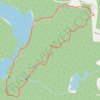
Lost Lake Loop Trail
Canada > British Columbia > Regional District of Fraser-Fort George > Area C (Chilako River/Nechako)
Trail is clearly marked with flagging tape and people have gone through and cut all 99% of the dead fall. The trail is over grown in places but you can still see the trail if you look hard enough. Some area of the trail are very well cleared so I would say it about 50/50 between needs work & clear.
Distance: 2.7 Km • Elevation gain: 64 m • Maximum elevation: 718 m